
Version: 0.0.1 | Published: 18 Feb 2022 | Updated: 1600 days ago
Synthetic Assessment of Global Distribution of Vulnerability to Climate Change: Maps and Data, 2005, 2050, and 2100
Dataset
Summary
Citation:
Yohe, G.; Malone, E.; Brenkert, A.; Schlesinger, M.; Meij, H.; Xing, X.; Lee,
D., 2006, Synthetic Assessment of Global Distribution of Vulnerability to
Climate Change: Maps and Data, 2005, 2050, and 2100, NASA Socioeconomic Data and
Applications Center (SEDAC), https://doi.org/10.7927/H4XG9P2R
DOI Name:
Documentation
Associated Media:
https://sedac.ciesin.columbia.edu/data/set/ipcc-synthetic-vulnerability-climate-2005-2050-2100/data-download
https://sedac.ciesin.columbia.edu/data/set/ipcc-synthetic-vulnerability-climate-2005-2050-2100/maps
https://sedac.ciesin.columbia.edu/data/set/ipcc-synthetic-vulnerability-climate-2005-2050-2100/maps/services
Description:
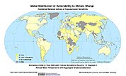
The Synthetic Assessment of Global Distribution of Vulnerability to Climate Change: Maps and Data, 2005, 2050, and 2100 data set consist of maps and vulnerability index to climate change of 100 countries based on the Vulnerability-Resilience Indicator Model (VRIM), which not only presents sensitivity to climate change stresses but allows the division of indicators into components that reflects sensitivity and adaptive capacity. It was produced in collaboration with the Wesleyan University, Joint Global Change Research Institute, University of Illinois and the Columbia University Center for International Earth Science Information Network (CIESIN).
Climatology/Meteorology/Atmosphere
Coverage
Spatial Aggregation:
Country
Start Date:
01 January 2005
End Date:
01 January 2100
Geographic Bounding Box
Lower Left Latitude:
-55.000000
Lower Left Longitude:
-180.000000
Upper Right Latitude:
90.000000
Upper Right Longitude:
180.000000
Provenance
Purpose:
To provide geographical portraits of vulnerability designed to incorporate both
exposure to climate change and national capacities to adapt.
Accessibility
Access
Access Service:
Users must register with NASA's User Registration System
Access URL:
Format:
- document
- map
- map service
Language:
en
Usage
References:
Resource Creator:
- Yohe, G.
- Malone, E.
- Brenkert, A.
- Schlesinger, M.
- Meij, H.
- Xing, X.
- Lee, D.
Origin
Name:
IPCC Data Catalogue